Blueprint Boilerplate

The Site Profile Plan
This profile view depicts the elevation slices taken from the plot plan, each horizontal line separates each slice of the hill, in 36" increments, indicating the house's location in relation to the existing grade. This aids the Environmental Potection Agency (a.k.a.: EPA) by providing what are know as cuts, or excavations, and fills, or backfilling. The EPA must agree with your intentions and plans when it comes to disturbing and redistributing the soil. Much of the coast line properties are under the auspices of CZM, or Coastal Zone Management, the government watch-dog agency overseeing the protection of our natural resources. Founded in 1972, the agency celebrates 33 years of service in 2005:
"The National Coastal Management Program is a federal-state partnership dedicated to comprehensive management of the nation’s coastal resources, ensuring their protection for future generations while balancing competing national economic, cultural and environmental interests.
The Coastal Zone Management Program (CZMP) is authorized by the Coastal Zone Management Act of 1972 and administered at the federal level by the Coastal Programs Division (CPD) within the National Oceanic and Atmospheric Administration's Office of Ocean and Coastal Resource Management (OCRM). The CPD is responsible for advancing national coastal management objectives and maintaining and strengthening state and territorial coastal management capabilities. It supports states through financial assistance, mediation, technical services and information, and participation in priority state, regional, and local forums.
The CZMP's leaves day-to-day management decisions at the state level in the 34 states and territories with federally approved coastal management programs. Currently, 95,376 national shoreline miles (99.9%) are managed by the Program. State and federal coastal zone management efforts are guided by the CZMP's Strategic Framework, which is organized around three major themes: Sustain Coastal Communities, Sustain Coastal Ecosystems, and Improve Government Efficiency."
The Latter excerpted from the Coastal Zone Management's website; for more information go to: http://coastalmanagement.noaa.gov/czm/
Boiler Plate Data
The construction information is a portion of what is known as "boiler plate data", (read: information repeatedly-printed on each succeeding model of boiler) necessary for the Department of Planning and Natural Resources (DPNR) to assess the needs and the intended use for the building.
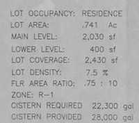
The size of the lot is mentioned, as is the coverage calculation, misrepresented in this instance (shhh.. ..don't say anything). The laws governing lot coverage (lot square footage vs. house square footage) are different in every Town, City, State, Island Chain, or Country for that matter. On St. Croix the lot coverage for our house is not 2,430 sq. feet, it is 2030 sq. ft., since the basement room is under the master bedroom suite, not a separate structure.
The type of zoning is also mentioned, in this case wrong again, honey, we are actually in R-2 zoning, not R-1. Againg, different rules, different places. R-2 zoning allows a second dwelling on the property, can you imagine another house on a 3/4 acre parcel?
Now you see the word cistern required and cistern provided, this is no joke. The Islands in the Caribbean all get their water from the same source, the oceans that surround us (desalinization) the clouds that are over us (rainfall) and in rare cases, ground water (driven wells). All of the houses built on the United States Virgin Islands must be equipped with a mandatory rainwater collection system. It's the law. What to do with this water to save it for future use? Collect it in cisterns, or storage tanks; also required as a part of your house, much like mandatory heating systems in New England, where I am from.
The houses are equipped with a gutter system and downspouts, all of which lead into the cistern itself. Depending on the type of construction, and the materials used, in some cases the gutters are added to a building afterward, as an add on, much like we do gutters up North, except theses downspouts lead into the cistern for storage until it is needed by the household.
In the same manner that a well pump is used to fill a water tank from a dug or driven well, a water pump is used to extract the water from the cistern and store it under pressure for household use in a water tank. The pump runs only to fill and pressurize the water tank and this is how the water pressure is manitained in the cistern system.
When someone runs the water by taking a shower for example, the pressure in the piping system drops and this triggers an automatic control, called a pressure-trol, to make a connection from the power source to the pump motor. This pressure-trol maintains the constant pressure of up 40 or 45 pounds per square inch (psi) and it does this 24 / 7 / 365, or as long as there is power to the unit.
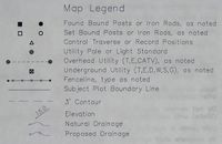
The map legend is similar to a roadmap legend, the key to the various icons represented on the drawing.


0 Comments:
Post a Comment
<< Home